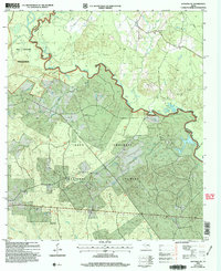
2004 Map of Kennard NE
USGS Topo · Published 2006About this map
The Neches River forms a winding natural boundary through the heart of the Davy Crockett National Forest, carving a landscape defined by deep sloughs and bottomland drainages. In this pocket of East Texas, the map reveals a quiet rural layout where social life centered on small, family-associated landmarks like Sweet Union Ch and the Wells Sch near the northern border. The terrain is notably dissected by numerous waterways, including Big Slough and Snake Creek, which drain into the main river channel.
Find a feature on this map
30 named features on this map. Tap any name to fly to it.
Don’t see what you’re looking for? This feature index may not catch every label — zoom into the map to look around manually.
Map Details
Editions of this 2004 Kennard NE Map
This is the sole edition of this map. No revisions or reprints were ever made.
Other maps of this area

1946 · Alto
USGS Topo · 1:62,500

1950 · Kennard NE
USGS Topo · 1:24,000

1950 · Ratcliff
USGS Topo · 1:24,000

1950 · Centralia
USGS Topo · 1:24,000

1951 · Kennard
USGS Topo · 1:24,000

1951 · Wells
USGS Topo · 1:24,000

1951 · Wells SW
USGS Topo · 1:24,000

1951 · Centralia
USGS Topo · 1:24,000

1951 · Kennard NE
USGS Topo · 1:24,000

1951 · Ratcliff
USGS Topo · 1:24,000