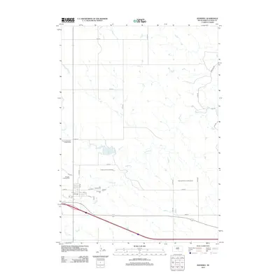
2012 Map of Kennebec
USGS Topo · Published 2012About this map
Kennebec serves as a central hub in Lyman County, situated near the headwaters of Medicine Cr and Grouse Cr. The town's grid is clearly defined by local streets such as Fulford St, N Main St, and 2nd St, reflecting its role as a regional core for agricultural transit and community life. Just north of the town center, Saint Michaels Cem and Hillsdale Cem provide significant points of interest for genealogists tracing family histories in this part of South Dakota.
Find a feature on this map
31 named features on this map. Tap any name to fly to it.
Don’t see what you’re looking for? This feature index may not catch every label — zoom into the map to look around manually.
Map Details
Editions of this 2012 Kennebec Map
This is the sole edition of this map. No revisions or reprints were ever made.
Other maps of this area

1952 · Reliance SW
USGS Topo · 1:24,000

1953 · Huron
USGS Topo · 1:250,000

1954 · Huron
USGS Topo · 1:250,000

1955 · Mitchell
USGS Topo · 1:250,000

1959 · Mitchell
USGS Topo · 1:250,000

1966 · Lower Brule SW
USGS Topo · 1:24,000

1966 · Joe Creek SE
USGS Topo · 1:24,000
1966 · Joe Creek SW
USGS Topo · 1:24,000
1978 · Brakke Dam
USGS Topo · 1:24,000
1978 · Lyman
USGS Topo · 1:24,000