
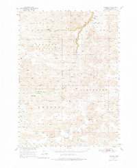
1950 Map of Kennedy
USGS Topo · Published 1952About this map
The Snake River winds through the Sandhills of Cherry County, Nebraska, defining a landscape of isolated ranches and scattered schools in the early 1950s. This USGS survey highlights the ranching culture of the era, recording family-named landmarks such as Piercy Ranch and Swanson Ranch. Small community hubs like Kennedy and the curiously named Tiny Town anchor the southern portion of the sheet, while the northern reaches include a section of the Nebraska National Forest.
Find a feature on this map
27 named features on this map. Tap any name to fly to it.
Don’t see what you’re looking for? This feature index may not catch every label — zoom into the map to look around manually.
Map Details
Editions of this 1950 Kennedy Map
2 editions found
Other maps of this area

1949 · Big Falls
USGS Topo · 1:62,500

1950 · Simeon
USGS Topo · 1:62,500

1950 · Powderhorn Valley
USGS Topo · 1:62,500

1950 · Kilgore
USGS Topo · 1:62,500

1950 · Valentine
USGS Topo · 1:62,500

1950 · Cody
USGS Topo · 1:62,500

1951 · Big Falls
USGS Topo · 1:62,500

1951 · Bull Lake
USGS Topo · 1:62,500

1951 · Brownlee
USGS Topo · 1:62,500

1957 · Valentine
USGS Topo · 1:250,000