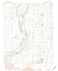
1983 Map of Kennett North
USGS Topo · Published 1984About this map
St Francis River and the Varney River define the intricate bottomlands of this border region, where the state line divides Clay County, Arkansas, from Dunklin County, Missouri. The landscape is a network of managed water and low-lying landforms like Sevenmile Island and Tenmile Island, protected by an extensive Levee system. This 1983 survey records a transitional era for the local infrastructure, noting several Abandoned railroad corridors that once linked rural communities. Small settlements and former rail stops such as Frisbee, White Oak, and Nimmons are scattered across the drainage basin, while the northern edge of Kennett begins to take shape in the south. The prevalence of drainage features like Camp Slough and various ditches illustrates the intensive engineering required to maintain the agricultural utility of these historic wetlands.
Find a feature on this map
28 named features on this map. Tap any name to fly to it.
Don’t see what you’re looking for? This feature index may not catch every label — zoom into the map to look around manually.
Map Details
Editions of this 1983 Kennett North Map
This is the sole edition of this map. No revisions or reprints were ever made.
Other maps of this area

1934 · Kennett
USGS Topo · 1:62,500

1940 · Pascola
USGS Topo · 1:62,500

1940 · Kennett
USGS Topo · 1:62,500

1940 · Hayti
USGS Topo · 1:62,500

1940 · Piggott
USGS Topo · 1:62,500

1955 · Pascola
USGS Topo · 1:62,500

1955 · Hayti
USGS Topo · 1:62,500

1956 · Kennett
USGS Topo · 1:62,500

1956 · Piggott
USGS Topo · 1:62,500

1956 · Dyersburg
USGS Topo · 1:250,000