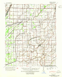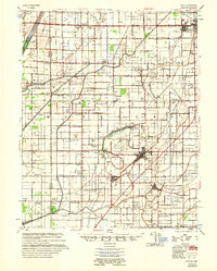
1955 Map of Hayti
USGS Topo · Published 1955About this map
Pemiscot Bayou and Little River wind through this heavily agricultural corner of the Missouri Bootheel, defining a landscape where drainage and flood control shaped settlement. The network of drainage ditches supports established communities like Hayti, Steele, and Cooter, which serve as hubs for the surrounding farm country. The presence of numerous small churches and schools, such as Zion Rock Ch and the Oak Ridge Douglas Sch & Ch, illustrates a decentralized rural social structure common before the mid-century consolidation of many such institutions.
Find a feature on this map
68 named features on this map. Tap any name to fly to it.
Don’t see what you’re looking for? This feature index may not catch every label — zoom into the map to look around manually.
Map Details
Editions of this 1955 Hayti Map
This is the sole edition of this map. No revisions or reprints were ever made.