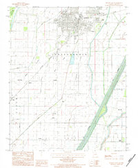
1983 Map of Kennett South
USGS Topo · Published 1984About this map
Kennett anchors the northern edge of this Bootheel landscape, where the flat alluvial plains of the Missouri-Arkansas border are defined by a complex network of drainage and flood control. The map illustrates the transition from the concentrated street grid of the city to the sprawling agricultural tracts of Independence and Salem townships. Significant water management features like The Floodway, Pole Cat Slough, and Sand Slough reveal the engineering required to maintain this lowland territory.
Find a feature on this map
27 named features on this map. Tap any name to fly to it.
Don’t see what you’re looking for? This feature index may not catch every label — zoom into the map to look around manually.
Map Details
Editions of this 1983 Kennett South Map
This is the sole edition of this map. No revisions or reprints were ever made.
Other maps of this area

1934 · Kennett
USGS Topo · 1:62,500

1940 · Pascola
USGS Topo · 1:62,500

1940 · Kennett
USGS Topo · 1:62,500

1940 · Hayti
USGS Topo · 1:62,500

1940 · Piggott
USGS Topo · 1:62,500

1955 · Pascola
USGS Topo · 1:62,500

1955 · Hayti
USGS Topo · 1:62,500

1956 · Kennett
USGS Topo · 1:62,500

1956 · Piggott
USGS Topo · 1:62,500

1956 · Dyersburg
USGS Topo · 1:250,000