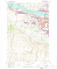
1964 Map of Kennewick
USGS Topo · Published 1974About this map
The Columbia River and Lake Wallula dominate the northern reach of this landscape, where the confluence with the Yakima River defines the border between Richland and Kennewick. During the mid-twentieth century, this area transitioned from a river-and-rail hub into a sprawling suburban center, evidenced by the development of West Highlands and South Highlands. Significant infrastructure for the region's agricultural and industrial base is visible, including the Highlift Canal, the Four Aqueduct, and the Burlington Northern and Union Pacific railroads. Local landmarks like Vista Field and the Tri-City Golf Course sit alongside essential community hubs such as Edison Sch and St Josephs Sch. The map also captures the topography of the southern hills, marked by Zintel Canyon and Amon Canyon, which contrast with the developed riverfront parks and residential blocks.
Find a feature on this map
48 named features on this map. Tap any name to fly to it.
Don’t see what you’re looking for? This feature index may not catch every label — zoom into the map to look around manually.
Map Details
Editions of this 1964 Kennewick Map
2 editions found
Other maps of this area

1917 · Pasco
USGS Topo · 1:125,000

1951 · Richland
USGS Topo · 1:62,500

1953 · Walla Walla
USGS Topo · 1:250,000

1958 · Walla Walla
USGS Topo · 1:250,000
1964 · Johnson Butte
USGS Topo · 1:24,000
1964 · Nine Canyon
USGS Topo · 1:24,000

1964 · Kennewick
USGS Topo · 1:24,000

1964 · Pasco
USGS Topo · 1:62,500
1964 · Pasco
USGS Topo · 1:24,000

1965 · Eltopia
USGS Topo · 1:62,500