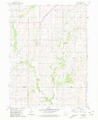
1981 Map of Kent
USGS Topo · Published 1981About this map
The settlement of Kent serves as a central point in this early 1980s topographical study of southwest Iowa, where the Burlington Northern railroad cuts a diagonal path through the prairie landscape. The area is defined by the complex drainage system of the Platte River, including the West Platte, Middle Platte, and East Platte branches. These waterways dictate the local geography, with numerous smaller tributaries like Saylings Creek and Todd Branch carving through the agricultural terrain of Grant and Platte townships.
Find a feature on this map
24 named features on this map. Tap any name to fly to it.
Don’t see what you’re looking for? This feature index may not catch every label — zoom into the map to look around manually.
Map Details
Editions of this 1981 Kent Map
This is the sole edition of this map. No revisions or reprints were ever made.
Other maps of this area

1954 · Omaha
USGS Topo · 1:250,000

1955 · Nebraska City
USGS Topo · 1:250,000

1957 · Nebraska City
USGS Topo · 1:250,000

1957 · Omaha
USGS Topo · 1:250,000

1958 · Omaha
USGS Topo · 1:250,000

1958 · Nebraska City
USGS Topo · 1:250,000

1980 · Merle Junction
USGS Topo · 1:24,000

1980 · Lenox
USGS Topo · 1:24,000

1980 · Creston East
USGS Topo · 1:24,000
1980 · Prescott
USGS Topo · 1:24,000