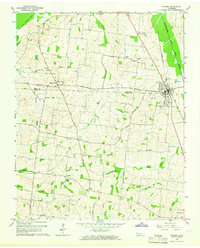
1965 Map of Kenton
USGS Topo · Published 1966About this map
Kenton straddles the line between Obion Co and Gibson Co during the mid-1960s, serving as a focal point for the region's agricultural and transport activity. The Gulf Mobile and Ohio railroad corridor anchors the eastern side of town, while a network of country roads like Dillard Road and Beth Page Road connect the outlying farmsteads. The landscape is defined by the winding paths of Grass Creek and the Rutherford Fork Obion River, with topographic features like Turtle Bend indicating the erratic natural drainage patterns common to the Western Tennessee bottomlands before extensive canalization.
Find a feature on this map
53 named features on this map. Tap any name to fly to it.
Don’t see what you’re looking for? This feature index may not catch every label — zoom into the map to look around manually.
Map Details
Editions of this 1965 Kenton Map
2 editions found
Other maps of this area

1950 · Obion
USGS Topo · 1:24,000

1950 · Rives
USGS Topo · 1:24,000

1951 · Obion
USGS Topo · 1:24,000

1951 · Rives
USGS Topo · 1:24,000

1953 · Dyer
USGS Topo · 1:24,000

1954 · Rutherford
USGS Topo · 1:24,000

1956 · Gardner
USGS Topo · 1:24,000

1956 · Dyersburg
USGS Topo · 1:250,000
1964 · Yorkville
USGS Topo · 1:24,000
1965 · Trimble
USGS Topo · 1:24,000