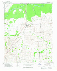
1965 Map of Trimble
USGS Topo · Published 1967About this map
Trimble serves as the central hub of this mid-1960s survey, situated along the Illinois Central railroad at the intersection of several regional routes including the Trimble Kenton Road. The surrounding landscape is defined by the winding course of the Obion River to the north, which is flanked by a complex system of a Drainage Canal and smaller tributaries like Dillard Creek and Hollow Creek. This drainage network suggests a landscape heavily modified for agriculture and flood control, further evidenced by the prominent Middle Rock Levee cutting across the central terrain.
Find a feature on this map
31 named features on this map. Tap any name to fly to it.
Don’t see what you’re looking for? This feature index may not catch every label — zoom into the map to look around manually.
Map Details
Editions of this 1965 Trimble Map
2 editions found
Other maps of this area

1925 · Reelfoot Lake
USGS Topo · 1:62,500

1939 · Reelfoot Lake
USGS Topo · 1:62,500

1939 · Dyersburg
USGS Topo · 1:62,500

1950 · Obion
USGS Topo · 1:24,000

1950 · Rives
USGS Topo · 1:24,000

1951 · Obion
USGS Topo · 1:24,000

1951 · Rives
USGS Topo · 1:24,000

1952 · Newbern
USGS Topo · 1:24,000

1952 · Lane
USGS Topo · 1:24,000

1956 · Reelfoot Lake
USGS Topo · 1:62,500