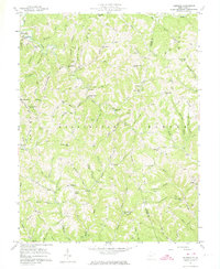
1957 Map of Kentuck
USGS Topo · Published 1974About this map
The hills of Jackson County and Roane County are defined here by a dense network of hollows and ridges, where small communities like Kentuck and Belgrove once thrived as centers of rural life. The 1957 field check reveals an era before widespread consolidation, where one-room schoolhouses like Sinaiville Sch, Enterprise Sch, and Plum Orchard Sch dotted the landscape alongside country churches such as Sinaiville Ch and Falling Water Ch.
Find a feature on this map
103 named features on this map. Tap any name to fly to it.
Don’t see what you’re looking for? This feature index may not catch every label — zoom into the map to look around manually.
Map Details
Editions of this 1957 Kentuck Map
3 editions found

Other maps of this area

1906 · Kenna
USGS Topo · 1:62,500

1906 · Walton
USGS Topo · 1:62,500

1907 · Kenna
USGS Topo · 1:62,500

1907 · Spencer
USGS Topo · 1:62,500

1907 · Walton
USGS Topo · 1:62,500

1907 · Ripley
USGS Topo · 1:62,500

1926 · Ripley
USGS Topo · 1:62,500

1928 · Spencer
USGS Topo · 1:62,500

1928 · Ripley
USGS Topo · 1:62,500

1954 · Charleston
USGS Topo · 1:250,000