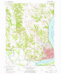
1964 Map of Keokuk
USGS Topo · Published 1977About this map
Keokuk sits at the vital confluence of the Mississippi River and the Des Moines River, serving as a critical tri-state hub for Iowa, Illinois, and Missouri. This mid-1960s survey captures the city's dense urban grid, featuring numerous educational and religious landmarks such as St Josephs Hospital, Cardinal Stritch High Sch, and St Peters Sch. The presence of the National Cemetery and Oakland Cemetery alongside the Keokuk Corporate Boundary reflects the deep civic history of this river port. Beyond the city center, the landscape transitions into industrial and recreational zones, including the Keokuk Municipal Airport and the Sportsmans Park Racetrack. To the north and west, smaller settlements like Summitville and Mooar are connected by the Chicago Rock Island and Pacific railroad, while natural features like The Yellow Banks and Sugar Creek define the outlying terrain.
Find a feature on this map
61 named features on this map. Tap any name to fly to it.
Don’t see what you’re looking for? This feature index may not catch every label — zoom into the map to look around manually.
Map Details
Editions of this 1964 Keokuk Map
Other maps of this area

1903 · Kahoka
USGS Topo · 1:125,000

1936 · Keokuk
USGS Topo · 1:62,500

1936 · Fort Madison
USGS Topo · 1:62,500

1949 · Wayland
USGS Topo · 1:24,000

1949 · Kahoka SE
USGS Topo · 1:24,000

1950 · Kahoka SE
USGS Topo · 1:24,000

1950 · Wayland
USGS Topo · 1:24,000

1950 · Keokuk
USGS Topo · 1:62,500

1958 · Burlington
USGS Topo · 1:250,000

1961 · Burlington
USGS Topo · 1:250,000