
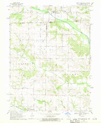
1968 Map of Keosauqua
USGS Topo · Published 1970About this map
The Des Moines River makes a dramatic oxbow turn around Keosauqua, the prominent county seat of Van Buren County. This 1960s landscape is characterized by a dense concentration of small family and community burial grounds, including Oak Lawn Cem, Purdom Cem, and Fellows Cem, which offer a clear map for genealogical research. The river bend dictates the town's orientation, with the Chicago Rock Island and Pacific railroad line cutting through the northeast corner across Washington township.
Find a feature on this map
26 named features on this map. Tap any name to fly to it.
Don’t see what you’re looking for? This feature index may not catch every label — zoom into the map to look around manually.
Map Details
Editions of this 1968 Keosauqua Map
This is the sole edition of this map. No revisions or reprints were ever made.
Other maps of this area

1954 · Centerville
USGS Topo · 1:250,000

1957 · Centerville
USGS Topo · 1:250,000

1958 · Centerville
USGS Topo · 1:250,000

1958 · Burlington
USGS Topo · 1:250,000

1961 · Burlington
USGS Topo · 1:250,000

1963 · Burlington
USGS Topo · 1:250,000

1965 · Douds
USGS Topo · 1:24,000

1968 · Anson
USGS Topo · 1:24,000

1968 · Bonaparte
USGS Topo · 1:24,000
1968 · Mount Sterling
USGS Topo · 1:24,000