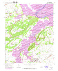
1967 Map of Keota
USGS Topo · Published 1979About this map
Strip Mines cut deep across the hills of Liberty and Sans Bois in this mid-century topographic survey of Haskell County. The landscape is defined by the significant footprint of the Robert S. Kerr Reservoir, which occupies the broad alluvial plains of the Arkansas River, Sadie Bottom, and Saylor Bottom. While much of the low-lying terrain is inundated, the settlement of Keota remains a central hub south of the water, supported by its local landmarks like the Keota Cem. Steep ridges such as Follet Mountain and Bellow Mountain rise sharply from the valley floor, creating a stark contrast between the industrial mining excavations and the riverine environment. Smaller communities and rural sites, including Red Hill, Shoat, and New Hope Ch, provide essential context for researchers tracing the mid-century evolution of this river-valley region.
Find a feature on this map
26 named features on this map. Tap any name to fly to it.
Don’t see what you’re looking for? This feature index may not catch every label — zoom into the map to look around manually.
Map Details
Editions of this 1967 Keota Map
2 editions found
Other maps of this area

1900 · Sansbois
USGS Topo · 1:125,000

1900 · Sallisaw
USGS Topo · 1:125,000

1909 · Sans Bois
USGS Topo · 1:125,000

1911 · Sallisaw
USGS Topo · 1:125,000

1911 · Sansbois
USGS Topo · 1:125,000

1946 · Fort Smith
USGS Topo · 1:250,000

1962 · Stigler East
USGS Topo · 1:24,000
1963 · Stigler NE
USGS Topo · 1:24,000
1964 · Stigler NE
USGS Topo · 1:24,000

1965 · Fort Smith
USGS Topo · 1:250,000