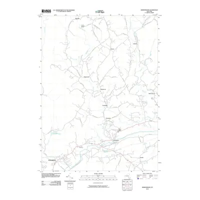
2010 Map of Kerhonkson
USGS Topo · Published 2010About this map
Wawarsing and the surrounding valley settlements in Ulster County are defined by a complex network of creeks and local roads as they appeared in 2010. The landscape is shaped by the descent of Vernooy Kill and Mombaccus Creek toward the Rondout Creek corridor, where the village of Kerhonkson serves as a central hub. Distinctive features like the Frank Utter Colony Farm and the Kerhonkson Reservoir indicate the region's agricultural roots and infrastructure needs. Small, dispersed settlements such as Pataukunk, Cherrytown, and Mettacahonts are connected by a web of historically named thoroughfares including Old Mine Rd and Berme Rd. These road names and the presence of the Piolis Brookside Airport reflect a community that has balanced rural residential growth with longstanding transit routes through the Catskill foothills.
Find a feature on this map
69 named features on this map. Tap any name to fly to it.
Don’t see what you’re looking for? This feature index may not catch every label — zoom into the map to look around manually.
Map Details
Editions of this 2010 Kerhonkson Map
This is the sole edition of this map. No revisions or reprints were ever made.
Other maps of this area

1901 · Rosendale
USGS Topo · 1:62,500

1903 · Newburg
USGS Topo · 1:62,500

1903 · Rosendale
USGS Topo · 1:62,500

1903 · Slide Mountain
USGS Topo · 1:62,500

1904 · Ellenville
USGS Topo · 1:62,500

1905 · Slide Mountain
USGS Topo · 1:62,500

1906 · Ellenville
USGS Topo · 1:62,500

1942 · West Shokan
USGS Topo · 1:24,000
1942 · Ashokan
USGS Topo · 1:24,000

1942 · Lackawack
USGS Topo · 1:24,000