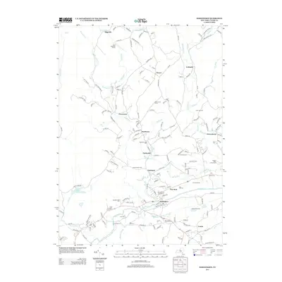
2013 Map of Kerhonkson
USGS Topo · Published 2013About this map
Kerhonkson serves as a primary hub in this Ulster County landscape, situated where the Rondout Cr meets the tributary waters of Mine Hole Brook. The map reveals a high concentration of agricultural and specialized land uses, including Sugarbrook Maple Farm, One Earth Farm, and the Catskill Native Nursery. These local names, alongside family-identified holdings like Frank Utter Colony Farm and Kelder's Farm, underscore a region defined by its rural heritage and active farmsteads.
Find a feature on this map
164 named features on this map. Tap any name to fly to it.
Don’t see what you’re looking for? This feature index may not catch every label — zoom into the map to look around manually.
Map Details
Editions of this 2013 Kerhonkson Map
This is the sole edition of this map. No revisions or reprints were ever made.
Other maps of this area

1901 · Rosendale
USGS Topo · 1:62,500

1903 · Newburg
USGS Topo · 1:62,500

1903 · Rosendale
USGS Topo · 1:62,500

1903 · Slide Mountain
USGS Topo · 1:62,500

1904 · Ellenville
USGS Topo · 1:62,500

1905 · Slide Mountain
USGS Topo · 1:62,500

1906 · Ellenville
USGS Topo · 1:62,500

1942 · West Shokan
USGS Topo · 1:24,000
1942 · Ashokan
USGS Topo · 1:24,000

1942 · Lackawack
USGS Topo · 1:24,000