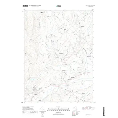
2019 Map of Kerhonkson
USGS Topo · Published 2019About this map
Rondout Creek carves a central path through this section of Ulster County, anchoring a valley where the historic hamlets of Kerhonkson and Wawarsing reside. The landscape is defined by the convergence of numerous waterways, including Vernoooy Kill and Rochester Cr, which historically powered local industries before the region transitioned toward its modern residential and recreational character. To the north, the terrain rises into the foothills, where smaller settlements like Cherrytown, Tabasco, and Mombaccus are linked by a dense network of mountain roads such as Samsonville-Kerhonkson Rd. Cultural and community markers are well-preserved, including the Rochester Center Cem and the Pine Bush Cem. Near Lyon Lake, a series of distinct trail or terrain labels like Chupacabra and Galloping Gert suggest a modern layer of recreational use overlaying the older agricultural and woodland footprints.
Find a feature on this map
135 named features on this map. Tap any name to fly to it.
Don’t see what you’re looking for? This feature index may not catch every label — zoom into the map to look around manually.
Map Details
Editions of this 2019 Kerhonkson Map
This is the sole edition of this map. No revisions or reprints were ever made.
Other maps of this area

1901 · Rosendale
USGS Topo · 1:62,500

1903 · Newburg
USGS Topo · 1:62,500

1903 · Rosendale
USGS Topo · 1:62,500

1903 · Slide Mountain
USGS Topo · 1:62,500

1904 · Ellenville
USGS Topo · 1:62,500

1905 · Slide Mountain
USGS Topo · 1:62,500

1906 · Ellenville
USGS Topo · 1:62,500

1942 · West Shokan
USGS Topo · 1:24,000
1942 · Ashokan
USGS Topo · 1:24,000

1942 · Lackawack
USGS Topo · 1:24,000