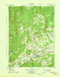
1943 Map of Kerhonkson
USGS Topo · Published 1943About this map
Kerhonkson and the surrounding townships of Rochester and Wawarsing are captured here during World War II, showing a landscape defined by the New York Ontario and Western railroad and the Rondout Creek. The valley floor is densely populated with community institutions, including Kerhonkson High School and Soccanissing School, while the higher elevations are dotted with family-named homesteads such as W. Kruger and G. Kortright.
Find a feature on this map
66 named features on this map. Tap any name to fly to it.
Don’t see what you’re looking for? This feature index may not catch every label — zoom into the map to look around manually.
Map Details
Editions of this 1943 Kerhonkson Map
This is the sole edition of this map. No revisions or reprints were ever made.
Other maps of this area

1901 · Rosendale
USGS Topo · 1:62,500

1903 · Newburg
USGS Topo · 1:62,500

1903 · Rosendale
USGS Topo · 1:62,500

1903 · Slide Mountain
USGS Topo · 1:62,500

1904 · Ellenville
USGS Topo · 1:62,500

1905 · Slide Mountain
USGS Topo · 1:62,500

1906 · Ellenville
USGS Topo · 1:62,500

1942 · West Shokan
USGS Topo · 1:24,000
1942 · Ashokan
USGS Topo · 1:24,000

1942 · Lackawack
USGS Topo · 1:24,000