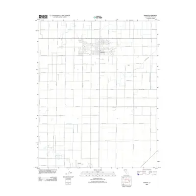
2012 Map of Kerman
USGS Topo · Published 2012About this map
Agricultural and industrial patterns of the San Joaquin Valley are visible in the grid-based layout of Kerman. The town's concentrated residential blocks contrast with the surrounding orchard and field lands, which are supported by a complex irrigation network including the Deadwood Ditch, Thompson Extension Canal, and Dry Creek Canal. To the south, the landscape shifts toward industrial activity at the Raisin City Oil Field, a significant landmark for the regional petroleum economy. Local transportation is defined by long, straight arterial routes like W Kearney Blvd and S McMullin Grade, which facilitate the movement of goods from the fields and oil wells. Other features such as Bland Field and the central Po locate key community and aviation infrastructure within this highly managed landscape.
Find a feature on this map
52 named features on this map. Tap any name to fly to it.
Don’t see what you’re looking for? This feature index may not catch every label — zoom into the map to look around manually.
Map Details
Editions of this 2012 Kerman Map
This is the sole edition of this map. No revisions or reprints were ever made.
Other maps of this area

1923 · Kearney Park
USGS Topo · 1:31,680

1923 · Herndon
USGS Topo · 1:31,680

1923 · Biola
USGS Topo · 1:31,680

1924 · Jamesan
USGS Topo · 1:31,680

1924 · Gravelly Ford
USGS Topo · 1:31,680

1925 · Helm
USGS Topo · 1:31,680

1925 · San Joaquin
USGS Topo · 1:31,680

1925 · Raisin
USGS Topo · 1:31,680
1946 · Madera
USGS Topo · 1:62,500
1946 · Kearney Park
USGS Topo · 1:24,000