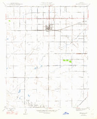
1947 Map of Kerman
USGS Topo · Published 1947About this map
The agricultural town of Kerman sits at the junction of the Southern Pacific railroad and early Central Valley road networks. Revised just after the war in 1946, this survey illustrates a landscape transitioning from traditional ranching to intensive irrigation, evidenced by the extensive network of waterways like the Houghton Canal, Empire Ditch, and Bishop Ditch. These canals supported the orchards and vineyards that defined the regional economy, while the southern reaches of the quadrangle show the emergence of Oil Fields and numerous water wells critical for local industry.
Find a feature on this map
25 named features on this map. Tap any name to fly to it.
Don’t see what you’re looking for? This feature index may not catch every label — zoom into the map to look around manually.
Map Details
Editions of this 1947 Kerman Map
This is the sole edition of this map. No revisions or reprints were ever made.
Other maps of this area

1923 · Kearney Park
USGS Topo · 1:31,680

1923 · Herndon
USGS Topo · 1:31,680

1923 · Biola
USGS Topo · 1:31,680

1924 · Jamesan
USGS Topo · 1:31,680

1924 · Gravelly Ford
USGS Topo · 1:31,680

1925 · Helm
USGS Topo · 1:31,680

1925 · San Joaquin
USGS Topo · 1:31,680

1925 · Raisin
USGS Topo · 1:31,680
1946 · Madera
USGS Topo · 1:62,500
1946 · Kearney Park
USGS Topo · 1:24,000