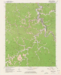
1963 Map of Kermit
USGS Topo · Published 1975About this map
Tug Fork carves a sharp, winding boundary between Kentucky and West Virginia, defining the settlement patterns and industrial infrastructure of this central Appalachian landscape. Along its banks, the Norfolk and Western railroad services the coal-rich corridor, connecting riverfront towns like Kermit, Warfield, and Stepptown. The map reveals a high density of small, valley-bottom communities and family-named landmarks, such as Greyeagle and Lovely, alongside numerous rural institutions like the Gospel Light Ch and Triplett Sch.
Find a feature on this map
109 named features on this map. Tap any name to fly to it.
Don’t see what you’re looking for? This feature index may not catch every label — zoom into the map to look around manually.
Map Details
Editions of this 1963 Kermit Map
4 editions found
Other maps of this area

1886 · Prestonsburg
USGS Topo · 1:125,000

1887 · Warfield
USGS Topo · 1:125,000

1891 · Warfield
USGS Topo · 1:125,000

1892 · Prestonsburg
USGS Topo · 1:125,000

1910 · Naugatuck
USGS Topo · 1:48,000

1912 · Naugatuck
USGS Topo · 1:62,500

1914 · Laynesville
USGS Topo · 1:48,000

1914 · Inez
USGS Topo · 1:48,000

1915 · Williamson
USGS Topo · 1:48,000

1915 · Naugatuck
USGS Topo · 1:48,000