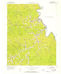
1954 Map of Kermit
USGS Topo · Published 1955About this map
The Tug Fork carves a winding boundary between Kentucky and West Virginia, defining the eastern edge of this mid-century survey. Along its banks, the settlements of Warfield, Beauty, and Lovely center a landscape heavily shaped by early energy extraction, evidenced by the numerous Gas Wells scattered throughout the steep hollows. The interior is characterized by a dense network of mountain schools and family cemeteries that speak to the isolated rural life of the era, including the Head of Blacklog Fork Sch and the Marcum Cem on Groundhog Ridge. Local geography is intricately detailed by named branches and forks such as Blacklog Fork, Crooked Creek, and Emily Creek, while the presence of Farley Ch and various schoolhouses like the Mouth of Peter Cave Fork Sch suggests a community organized around remote creek-side social centers before modern infrastructure unified the region.
Find a feature on this map
71 named features on this map. Tap any name to fly to it.
Don’t see what you’re looking for? This feature index may not catch every label — zoom into the map to look around manually.
Map Details
Editions of this 1954 Kermit Map
This is the sole edition of this map. No revisions or reprints were ever made.
Other maps of this area

1886 · Prestonsburg
USGS Topo · 1:125,000

1887 · Warfield
USGS Topo · 1:125,000

1891 · Warfield
USGS Topo · 1:125,000

1892 · Prestonsburg
USGS Topo · 1:125,000

1910 · Naugatuck
USGS Topo · 1:48,000

1912 · Naugatuck
USGS Topo · 1:62,500

1914 · Laynesville
USGS Topo · 1:48,000

1914 · Inez
USGS Topo · 1:48,000

1915 · Williamson
USGS Topo · 1:48,000

1915 · Naugatuck
USGS Topo · 1:48,000