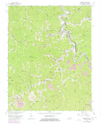
1963 Map of Kermit
USGS Topo · Published 1978About this map
Tug Fork carves a deep, winding boundary between Kentucky and West Virginia on this 1963 survey, where the Norfolk and Western railway snakes alongside the river. The settlement pattern follows the narrow valley floors and ridgelines of the Appalachian plateau, with small communities like Kermit and Warfield serving as local hubs. Cultural landmarks of the mid-20th century are evident, including a Drive-in Theater near Lovely and the Cassidy Lookout Tower presiding over the higher elevations to the west. This edition, updated in the late 1970s, captures the region's religious and family heritage through numerous hillside cemeteries and churches such as Gospel Light Ch and Old Zion Ch. The landscape also bears the marks of resource extraction, with multiple mines and strip mines located near Selwyn and the southern reaches of the quadrangle.
Find a feature on this map
105 named features on this map. Tap any name to fly to it.
Don’t see what you’re looking for? This feature index may not catch every label — zoom into the map to look around manually.
Map Details
Editions of this 1963 Kermit Map
4 editions found
Other maps of this area

1886 · Prestonsburg
USGS Topo · 1:125,000

1887 · Warfield
USGS Topo · 1:125,000

1891 · Warfield
USGS Topo · 1:125,000

1892 · Prestonsburg
USGS Topo · 1:125,000

1910 · Naugatuck
USGS Topo · 1:48,000

1912 · Naugatuck
USGS Topo · 1:62,500

1914 · Laynesville
USGS Topo · 1:48,000

1914 · Inez
USGS Topo · 1:48,000

1915 · Williamson
USGS Topo · 1:48,000

1915 · Naugatuck
USGS Topo · 1:48,000