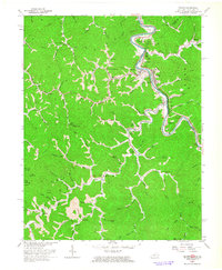
1963 Map of Kermit
USGS Topo · Published 1964About this map
The Tug Fork river carves a sharp boundary between Kentucky and West Virginia, defining the community life of Kermit and Warfield in the early 1960s. This survey illustrates a landscape deeply shaped by the Norfolk and Western Ry and a network of mountain hollows where settlements like Stepptown, Beauty, and Pilgrim are connected by winding creeks. The map documents the region's industrial and social infrastructure, from numerous Oil Wells and a Pipeline to local landmarks like the Drive-in Theater and the Cassidy Lookout Tower. Family history is preserved in named sites such as Brewer Cem, Stepp Cem, and the Kirk Cem, alongside country institutions like the Marrowbone Sch and Gospel Light Ch. The concentration of dwellings along the riverbanks versus the relative isolation of Ashlog and Threeforks highlights the topographic constraints of the Central Appalachian terrain.
Find a feature on this map
85 named features on this map. Tap any name to fly to it.
Don’t see what you’re looking for? This feature index may not catch every label — zoom into the map to look around manually.
Map Details
Editions of this 1963 Kermit Map
4 editions found
Other maps of this area

1886 · Prestonsburg
USGS Topo · 1:125,000

1887 · Warfield
USGS Topo · 1:125,000

1891 · Warfield
USGS Topo · 1:125,000

1892 · Prestonsburg
USGS Topo · 1:125,000

1910 · Naugatuck
USGS Topo · 1:48,000

1912 · Naugatuck
USGS Topo · 1:62,500

1914 · Laynesville
USGS Topo · 1:48,000

1914 · Inez
USGS Topo · 1:48,000

1915 · Williamson
USGS Topo · 1:48,000

1915 · Naugatuck
USGS Topo · 1:48,000