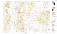
1988 Map of Kern Mountains
USGS Topo · Published 1988About this map
The Schell Creek Range and the Kern Mountains dominate this high-desert landscape in eastern Nevada and western Utah during the late 1980s. This survey records the distinct spatial relationship between the rugged peaks of the Humboldt National Forest and the broad, flat expanses of Steptoe Valley and Antelope Valley. Local history is anchored at sites like Schellbourne and the mining-associated names of Aurum and Tungstonia, which sit near the northern reaches of the Spring Valley Depression. The map also captures the Goshute Indian Reservation in the northeast, where Spring Creek Flat transitions into the South Mountains. Numerous water sources, including Miram Spring and Madalina Spring, dot the base of the ranges, illustrating the critical role of springs in supporting the remote settlements and stations of White Pine County.
Find a feature on this map
59 named features on this map. Tap any name to fly to it.
Don’t see what you’re looking for? This feature index may not catch every label — zoom into the map to look around manually.
Map Details
Editions of this 1988 Kern Mountains Map
2 editions found
Other maps of this area

1908 · Fish Springs
USGS Topo · 1:250,000

1910 · Fish Springs
USGS Topo · 1:250,000

1925 · Gold Hill
USGS Topo · 1:62,500

1928 · Gold Hill
USGS Topo · 1:62,500

1952 · Ely
USGS Topo · 1:125,000

1953 · Tooele
USGS Topo · 1:250,000

1953 · Delta
USGS Topo · 1:250,000

1955 · Tooele
USGS Topo · 1:250,000

1955 · Elko
USGS Topo · 1:250,000

1956 · Ely
USGS Topo · 1:250,000