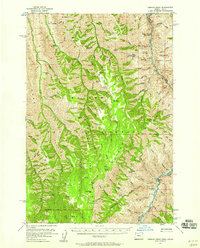
1954 Map of Kernan Point
USGS Topo · Published 1958About this map
Snake River canyon walls define the eastern border of this mid-century survey, marking the state line between Oregon and Idaho. The landscape is dominated by a succession of high ridges, including Sleepy Ridge, Jackey Ridge, and Windy Ridge, which separate deep drainages like Lightning Creek and Mormon Creek. High-elevation plateaus such as Lord Flat and Mormon Flat appear as significant grazing or transit points within the Wallowa National Forest.
Find a feature on this map
96 named features on this map. Tap any name to fly to it.
Don’t see what you’re looking for? This feature index may not catch every label — zoom into the map to look around manually.
Map Details
Editions of this 1954 Kernan Point Map
3 editions found
Other maps of this area

1922 · He Devil
USGS Topo · 1:48,000

1938 · Riggins
USGS Topo · 1:96,000

1945 · Riggins
USGS Topo · 1:125,000

1954 · Imnaha
USGS Topo · 1:62,500

1954 · Kernan Point
USGS Topo · 1:62,500

1954 · Harl Butte
USGS Topo · 1:62,500

1955 · Grangeville
USGS Topo · 1:250,000

1957 · He Devil
USGS Topo · 1:62,500

1959 · Grangeville
USGS Topo · 1:250,000

1963 · Cactus Mtn
USGS Topo · 1:24,000