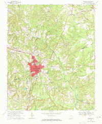
1969 Map of Kershaw
USGS Topo · Published 1971About this map
The town of Kershaw sits at the intersection of industry and transit in the late 1960s, straddling the line between Lancaster and Kershaw Counties. The Southern railroad line bisects the community, serving the established commercial center and local infrastructure like the Filtration Plant and City Reservoir. A notable industrial legacy is evident to the northeast at the Haile Gold Mine, situated along Haile Gold Mine Creek, indicating the area's geological history beyond simple agriculture.
Find a feature on this map
45 named features on this map. Tap any name to fly to it.
Don’t see what you’re looking for? This feature index may not catch every label — zoom into the map to look around manually.
Map Details
Editions of this 1969 Kershaw Map
3 editions found
Other maps of this area

1935 · Camden
USGS Topo · 1:48,000

1938 · Camden
USGS Topo · 1:62,500

1941 · Spartanburg
USGS Topo · 1:250,000

1942 · Camden
USGS Topo · 1:125,000

1953 · Spartanburg
USGS Topo · 1:250,000

1960 · Spartanburg
USGS Topo · 1:250,000

1963 · Spartanburg
USGS Topo · 1:250,000

1964 · Spartanburg
USGS Topo · 1:250,000

1967 · Mount Pisgah
USGS Topo · 1:24,000

1968 · Heath Springs
USGS Topo · 1:24,000