
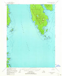
1948 Map of Ketchikan A-6
USGS Topo · Published 1957About this map
Gravina Island and its maritime approaches dominate this post-war survey of the Alexander Archipelago, showing the coastal landscape before modern development. The island's interior is defined by prominent heights like Flat Mountain and Punch Hill, while its southern tip at Dall Head marks the entrance to Nichols Passage. On the opposite side of the broad Clarence Strait, the eastern shoreline of Prince of Wales Island reveals a series of sheltered anchorages, including Port Johnson and Menefee Anchorage. A lone Sawmill on the eastern shore of Gravina Island and a small Cabin at Rip Point provide evidence of the era's small-scale coastal industry and habitation. The entire land area is contained within the Tongass National Forest, preserving the intricate network of inlets like Bostwick Inlet and Nelson Cove as they appeared in the late 1940s.
Find a feature on this map
28 named features on this map. Tap any name to fly to it.
Don’t see what you’re looking for? This feature index may not catch every label — zoom into the map to look around manually.
Map Details
Editions of this 1948 Ketchikan A-6 Map
2 editions found
Other maps of this area

1948 · Prince Rupert D-6
USGS Topo · 1:63,360

1948 · Craig A-1
USGS Topo · 1:63,360

1948 · Dixon Entrance D-1
USGS Topo · 1:63,360

1949 · Craig B-1
USGS Topo · 1:63,360

1950 · Craig B-1
USGS Topo · 1:63,360

1951 · Prince Rupert
USGS Topo · 1:250,000

1951 · Dixon Entrance
USGS Topo · 1:250,000

1951 · Prince Rupert D-6
USGS Topo · 1:63,360

1952 · Ketchikan
USGS Topo · 1:250,000

1953 · Ketchikan B-6
USGS Topo · 1:63,360