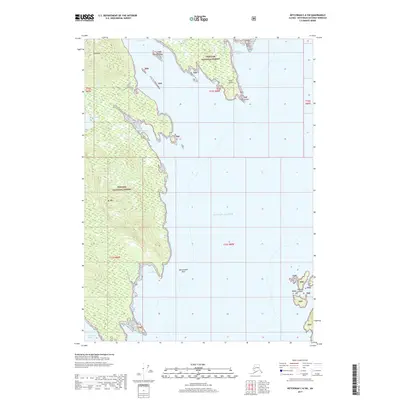
2017 Map of Ketchikan C-6 SW
USGS Topo · Published 2017About this map
The Tongass National Forest dominates this coastal Alaska landscape, where steep maritime peaks meet the intricate inlets of the Alexander Archipelago. Significant elevations like Gold Mtn and Mt Marr tower over the eastern shoreline of the Clarence Strait, defining a terrain marked by deep glacial carvings and isolated freshwater bodies such as Smugglers Lake. The maritime geography is characterized by sheltered anchorages like Helm Bay and Bond Bay, which are protected by numerous landforms including Thomas Island and the Tatoosh Islands. This 2017 survey details the complex interface of the Gulf of Alaska with the mainland, showing how the coastal topography creates a series of protected coves, such as Wadding Cove and Smugglers Cove, separated by prominent features like Helm Point.
Find a feature on this map
23 named features on this map. Tap any name to fly to it.
Don’t see what you’re looking for? This feature index may not catch every label — zoom into the map to look around manually.
Map Details
Editions of this 2017 Ketchikan C-6 SW Map
This is the sole edition of this map. No revisions or reprints were ever made.
Other maps of this area

1949 · Ketchikan C-6
USGS Topo · 1:63,360

1949 · Craig B-1
USGS Topo · 1:63,360

1950 · Craig B-1
USGS Topo · 1:63,360

1950 · Craig C-1
USGS Topo · 1:63,360

1951 · Craig C-1
USGS Topo · 1:63,360

1952 · Ketchikan
USGS Topo · 1:250,000

1952 · Ketchikan C-6
USGS Topo · 1:63,360

1953 · Ketchikan B-6
USGS Topo · 1:63,360

1954 · Ketchikan B-6
USGS Topo · 1:63,360

1955 · Ketchikan
USGS Topo · 1:250,000