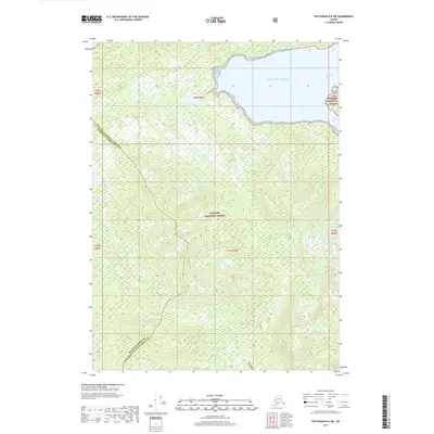
2017 Map of Ketchikan D-6 SW
USGS Topo · Published 2017About this map
Tongass National Forest dominates this coastal Alaska landscape, where the land meets the cold waters of the Gulf of Alaska. The terrain is defined by its dramatic shoreline and intricate drainage systems, featuring the narrow inlet of Spacious Bay and the isolated profile of Square Island. The interior is marked by the courses of Wasta Cr and Hofstad Cr, which carve through the dense forest towards the sea. This 2017 survey documents the jurisdictional boundary where Wrangell Borough and Ketchikan Gateway Borough meet, providing a modern record of this largely undeveloped wilderness. The map's detail is particularly useful for understanding the hydrologic patterns and topography of this remote section of Southeast Alaska, showing a landscape where natural boundaries still dictate the movement of water and life.
Find a feature on this map
13 named features on this map. Tap any name to fly to it.
Don’t see what you’re looking for? This feature index may not catch every label — zoom into the map to look around manually.
Map Details
Editions of this 2017 Ketchikan D-6 SW Map
This is the sole edition of this map. No revisions or reprints were ever made.
Other maps of this area

1949 · Ketchikan C-6
USGS Topo · 1:63,360

1949 · Craig D-1
USGS Topo · 1:63,360

1950 · Craig C-1
USGS Topo · 1:63,360

1951 · Craig C-1
USGS Topo · 1:63,360

1951 · Craig D-1
USGS Topo · 1:63,360

1952 · Ketchikan
USGS Topo · 1:250,000

1952 · Ketchikan C-6
USGS Topo · 1:63,360

1952 · Ketchikan D-6
USGS Topo · 1:63,360

1953 · Ketchikan D-6
USGS Topo · 1:63,360

1955 · Ketchikan
USGS Topo · 1:250,000