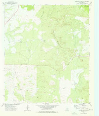
1973 Map of Ketchum Mountain
USGS Topo · Published 1976About this map
Ketchum Oil Field dominates the southwestern corner of this landscape, reflecting the petroleum-driven economy of Irion County in the early 1970s. The map shows a transition from the lower basins of South Liveoak Draw and Mc Dowell Draw up into the high plateau of Ketchum Mountain. This arid terrain is defined by ranching and energy extraction, with private holdings like the Magruder Ranch and Cox Ranch situated near intermittent watercourses and the Middle Concho River. Industrial infrastructure is prevalent throughout the area, including a prominent Pipeline and a central Pumping Sta. The presence of scattered Oil Wells and a Drill Hole indicates a period of active exploration and production on the Edwards Plateau during this era.
Find a feature on this map
15 named features on this map. Tap any name to fly to it.
Don’t see what you’re looking for? This feature index may not catch every label — zoom into the map to look around manually.
Map Details
Editions of this 1973 Ketchum Mountain Map
This is the sole edition of this map. No revisions or reprints were ever made.
Other maps of this area

1895 · Sherwood
USGS Topo · 1:125,000

1920 · Barnhart
USGS Topo · 1:62,500

1921 · Ketchum Mountain
USGS Topo · 1:62,500

1922 · Barnhart
USGS Topo · 1:62,500

1923 · Ketchum Mountain
USGS Topo · 1:62,500

1954 · San Angelo
USGS Topo · 1:250,000

1958 · San Angelo
USGS Topo · 1:250,000

1965 · San Angelo
USGS Topo · 1:250,000

1971 · Noelke
USGS Topo · 1:24,000
1971 · Barnhart
USGS Topo · 1:24,000