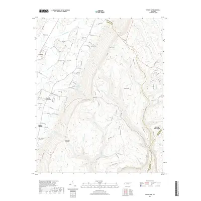
2019 Map of Ketner Gap
USGS Topo · Published 2019About this map
Walden Ridge and the sharp rise of the Cumberland Escarpment dominate this Tennessee landscape, where the Sequatchie River winds through its namesake valley. The area exhibits a distinct settlement pattern, with towns like Whitwell and Powells Crossroads established on the lower valley floors, while the higher elevations of Signal Mountain mark the eastern transition toward the Tennessee River drainage. The map reveals a dense network of family-named landmarks and cemeteries, such as Grayson Cem, Pickett Cem, and Barker Cem, which are vital for tracing local heritage along the boundaries of Sequatchie, Marion, and Hamilton counties. Major corridors like Suck Creek Rd and Old Chattanooga Hwy cut through the gaps, including Ketner Gap and Ditch Gap, illustrating how the terrain has historically dictated the movement of people and commerce through these mountain passes.
Find a feature on this map
102 named features on this map. Tap any name to fly to it.
Don’t see what you’re looking for? This feature index may not catch every label — zoom into the map to look around manually.
Map Details
Editions of this 2019 Ketner Gap Map
This is the sole edition of this map. No revisions or reprints were ever made.
Other maps of this area

1888 · Chattanooga
USGS Topo · 1:125,000

1893 · Chattanooga
USGS Topo · 1:125,000

1895 · Sewanee
USGS Topo · 1:125,000

1936 · Palmer
USGS Topo · 1:24,000

1936 · Daus
USGS Topo · 1:24,000

1936 · Henson Gap
USGS Topo · 1:24,000

1936 · Whitwell
USGS Topo · 1:24,000

1936 · Ketner Gap
USGS Topo · 1:24,000

1936 · Fairmount
USGS Topo · 1:24,000

1936 · Wauhatchie
USGS Topo · 1:24,000
Featured Places
- Signal Mountain, TN
- Whitwell, TN
- Powells Crossroads, TN
- Shirleyton, TN
- Sulphur Springs, Powells Crossroads