
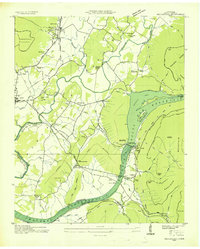
1936 Map of Ketner Gap
USGS Topo · Published 1936About this map
The Sequatchie Valley and the formidable heights of Walden Ridge dominate this 1936 topographic study, showing a landscape defined by the transition from river bottomlands to highland plateaus. In the valley, the Sequatchie River meanders through agricultural lands supported by the Nashville Chattanooga and St Louis Ry and settlements like Shirleyton and Crossroads. The era's technological footprint is evident through the Tenn Elec Pwr Co Trans Line and a dedicated Weather Observation Station at Ketner Gap. Local life centers around family names and rural institutions, including Hicks Chapel Sch, Looney Creek Ch, and numerous small burial grounds such as White Cem and Teague Cem. On the ridge, coal extraction is established at the Hassler Mine and Barnes Mine, illustrating the region's early industrial character.
Find a feature on this map
63 named features on this map. Tap any name to fly to it.
Don’t see what you’re looking for? This feature index may not catch every label — zoom into the map to look around manually.
Map Details
Editions of this 1936 Ketner Gap Map
This is the sole edition of this map. No revisions or reprints were ever made.
Other maps of this area

1888 · Chattanooga
USGS Topo · 1:125,000

1893 · Chattanooga
USGS Topo · 1:125,000

1895 · Sewanee
USGS Topo · 1:125,000

1936 · Palmer
USGS Topo · 1:24,000

1936 · Daus
USGS Topo · 1:24,000

1936 · Henson Gap
USGS Topo · 1:24,000

1936 · Whitwell
USGS Topo · 1:24,000

1936 · Fairmount
USGS Topo · 1:24,000

1936 · Wauhatchie
USGS Topo · 1:24,000
1936 · Sequatchie
USGS Topo · 1:24,000
Featured Places
- Signal Mountain, TN
- Whitwell, TN
- Powells Crossroads, TN
- Shirleyton, TN
- Sulphur Springs, Powells Crossroads