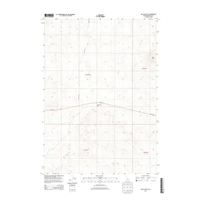
2013 Map of Kettle Butte
USGS Topo · Published 2013About this map
Kettle Butte and the volcanic outcrop of Twentymile Rock dominate this arid stretch of the Eastern Snake River Plain. This 2013 survey of Bonneville County captures a landscape defined by its distinctive geological formations and the sparse infrastructure of the high desert. Modern transportation corridors, specifically the W Arco Hwy and Mud Lake Rd, traverse the region, following the natural contours of the terrain. The presence of Taylor Well in the northern portion of the quadrangle highlights the critical importance of water access in this semi-arid environment, serving as a vital point for land management and local navigation. The map's detailed topography reveals the subtle volcanic rises and depressions characteristic of the region's ancient lava fields.
Find a feature on this map
9 named features on this map. Tap any name to fly to it.
Don’t see what you’re looking for? This feature index may not catch every label — zoom into the map to look around manually.
Map Details
Editions of this 2013 Kettle Butte Map
This is the sole edition of this map. No revisions or reprints were ever made.
Other maps of this area

1955 · Idaho Falls
USGS Topo · 1:250,000

1958 · Idaho Falls
USGS Topo · 1:250,000

1964 · Kettle Butte NE
USGS Topo · 1:24,000

1964 · Kettle Butte NW
USGS Topo · 1:24,000

1964 · Kettle Butte SW
USGS Topo · 1:24,000
1964 · Morgans Pasture NE
USGS Topo · 1:24,000
1964 · Butterfly Butte
USGS Topo · 1:24,000

1973 · Little Butte NE
USGS Topo · 1:24,000

1973 · Little Butte
USGS Topo · 1:24,000

1973 · Taber NE
USGS Topo · 1:24,000