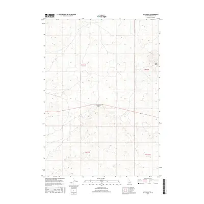
2017 Map of Kettle Butte
USGS Topo · Published 2017About this map
Kettle Butte rises as a prominent landmark in this southeastern Idaho landscape, situated within the lava-strewn plains of the Snake River Valley. This 2017 survey details a sparsely developed region of Bonneville County, where the volcanic geology is punctuated by features like Twentymile Rock. The map illustrates a strictly organized grid of townships and ranges, including t3n r34e and t3n r35e, reflecting the systematic land division of the West. Human presence is light, defined primarily by agricultural boundaries and the passage of Idaho State Highway 20, which cuts through the southern sections. For researchers, the document clarifies the relationship between the natural topographic rises of the buttes and the modern transportation corridors that navigate this arid environment.
Find a feature on this map
7 named features on this map. Tap any name to fly to it.
Don’t see what you’re looking for? This feature index may not catch every label — zoom into the map to look around manually.
Map Details
Editions of this 2017 Kettle Butte Map
This is the sole edition of this map. No revisions or reprints were ever made.
Other maps of this area

1955 · Idaho Falls
USGS Topo · 1:250,000

1958 · Idaho Falls
USGS Topo · 1:250,000

1964 · Kettle Butte NE
USGS Topo · 1:24,000

1964 · Kettle Butte NW
USGS Topo · 1:24,000

1964 · Kettle Butte SW
USGS Topo · 1:24,000
1964 · Morgans Pasture NE
USGS Topo · 1:24,000
1964 · Butterfly Butte
USGS Topo · 1:24,000

1973 · Little Butte NE
USGS Topo · 1:24,000

1973 · Little Butte
USGS Topo · 1:24,000

1973 · Taber NE
USGS Topo · 1:24,000