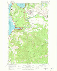
1969 Map of Kettle Falls
USGS Topo · Published 1972About this map
The Columbia River and Franklin D Roosevelt Lake dominate the western edge of this 1969 survey, illustrating the hydraulic geography of the Coulee Dam National Recreation Area. The landscape transitions from the river flats of West Kettle Falls up into the high terrain of the Huckleberry Mountain Range. The industrial and resource-based history of the region is evident in the cluster of mining operations such as the Broad Gauge Mine, Silver Queen Mine, and Blue Grouse Mine. These sites, along with the Burlington Northern railroad corridor, speak to an era of extraction and transport that defined northeastern Washington. Small social centers like the Meyers Falls Cemetery, a Convent, and the settlement of Ward provide a look at the community fabric near the Colville River and Meyers Falls Reservoir.
Find a feature on this map
51 named features on this map. Tap any name to fly to it.
Don’t see what you’re looking for? This feature index may not catch every label — zoom into the map to look around manually.
Map Details
Editions of this 1969 Kettle Falls Map
2 editions found
Other maps of this area

1927 · Chewelah
USGS Topo · 1:125,000

1929 · Colville
USGS Topo · 1:125,000

1930 · Chewelah
USGS Topo · 1:125,000

1933 · Colville
USGS Topo · 1:125,000

1936 · Marcus
USGS Topo · 1:96,000

1942 · Marcus
USGS Topo · 1:125,000

1948 · Kettle Falls
USGS Topo · 1:62,500

1950 · Inchelium
USGS Topo · 1:62,500

1951 · Kettle Falls
USGS Topo · 1:62,500

1952 · Echo Valley
USGS Topo · 1:24,000