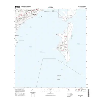
2015 Map of Key Biscayne
USGS Topo · Published 2015About this map
Miami and the northern reaches of Biscayne National Park anchor this coastal survey, which highlights the dense connectivity between the mainland and its barrier islands. The Rickenbacker Cswy spans the Intracoastal Waterway via the William M Powell Bridge, linking the mainland's Coconut Grove and Bay Heights to Virginia Key and the residential heart of Key Biscayne. The geography here is defined by complex water management and leisure spaces, from the developed shorelines of Mashta Island and Harbor Point to the expansive recreational stretches of Crandon Beach and Virginia Beach. Coastal navigation is detailed through various channels, including the Bear Cut, Dinner Key Channel, and the Cape Florida Channel, which leads toward the southern tip of the island at Cape Florida. This era of the landscape shows the matured infrastructure of the island communities and the protected waters of the Biscayne Flats.
Find a feature on this map
110 named features on this map. Tap any name to fly to it.
Don’t see what you’re looking for? This feature index may not catch every label — zoom into the map to look around manually.
Map Details
Editions of this 2015 Key Biscayne Map
This is the sole edition of this map. No revisions or reprints were ever made.
Other maps of this area

1947 · Key Biscayne
USGS Topo · 1:24,000

1948 · Soldier Key
USGS Topo · 1:24,000

1949 · Key Biscayne
USGS Topo · 1:24,000

1949 · Perrine
USGS Topo · 1:24,000

1950 · Hialeah
USGS Topo · 1:24,000

1950 · Miami
USGS Topo · 1:24,000

1950 · South Miami
USGS Topo · 1:24,000

1956 · Perrine
USGS Topo · 1:24,000

1956 · South Miami
USGS Topo · 1:24,000
1956 · Soldier Key
USGS Topo · 1:24,000