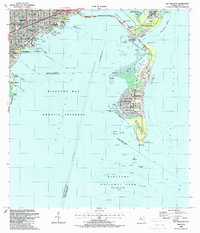
1988 Map of Key Biscayne
USGS Topo · Published 1988About this map
Biscayne Bay serves as the central focal point of this coastal survey, separating the burgeoning mainland neighborhoods of Miami and Coral Gables from the barrier islands. The mainland shoreline is dotted with cultural landmarks like the Vizcaya Museum and The Barnacle State Historic Site, while the inland Metrorail line indicates the era's urban transit development. Across the Rickenbacker Causeway, the islands of Virginia Key and Key Biscayne are defined by significant public and scientific institutions, including the Seaquarium, the Marine Stadium, and the Univ of Miami Marine Laboratory. The southern tip of the key is dominated by the Bill Baggs Cape Florida State Recreation Area, anchored by the Old Lighthouse Tower. Detailed bathymetry throughout the Biscayne Bay Aquatic Preserve highlights numerous channels and shoals, such as Bear Cut and Coral Shoal, which were critical for local navigation before the establishment of Biscayne National Park at the sheet's southern edge.
Find a feature on this map
75 named features on this map. Tap any name to fly to it.
Don’t see what you’re looking for? This feature index may not catch every label — zoom into the map to look around manually.
Map Details
Editions of this 1988 Key Biscayne Map
This is the sole edition of this map. No revisions or reprints were ever made.
Other maps of this area

1947 · Key Biscayne
USGS Topo · 1:24,000

1948 · Soldier Key
USGS Topo · 1:24,000

1949 · Key Biscayne
USGS Topo · 1:24,000

1949 · Perrine
USGS Topo · 1:24,000

1950 · Hialeah
USGS Topo · 1:24,000

1950 · Miami
USGS Topo · 1:24,000

1950 · South Miami
USGS Topo · 1:24,000

1956 · Perrine
USGS Topo · 1:24,000

1956 · South Miami
USGS Topo · 1:24,000
1956 · Soldier Key
USGS Topo · 1:24,000