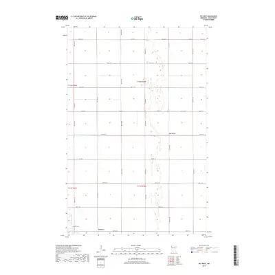
2019 Map of Key West
USGS Topo · Published 2019About this map
Key West and Davidson anchor this section of Polk County, where the landscape is defined by the rigid geometry of the Public Land Survey System. The area sits within the Red River Valley, characterized by extensive agricultural drainage networks like County Ditch Number One Hundred Twenty Six. These man-made channels support the intensive farming of the region, running parallel to the long, straight stretches of Co Hwy 19 and 180th St SW. In the southwestern corner, Grand Marais Creek provides a natural contrast to the drainage ditches, meandering near the Nesbit Cem. This 2019 survey documents the modern rural infrastructure of the township, showing how historic crossroads like Davidson continue to serve as local landmarks amidst the vast sections of T151N and T152N.
Find a feature on this map
22 named features on this map. Tap any name to fly to it.
Don’t see what you’re looking for? This feature index may not catch every label — zoom into the map to look around manually.
Map Details
Editions of this 2019 Key West Map
This is the sole edition of this map. No revisions or reprints were ever made.
Other maps of this area

1918 · Angus
USGS Topo · 1:62,500

1918 · Warren
USGS Topo · 1:62,500

1952 · Grand Forks
USGS Topo · 1:250,000

1952 · Thief River Falls
USGS Topo · 1:250,000

1953 · Crookston
USGS Topo · 1:62,500

1955 · Warren
USGS Topo · 1:62,500

1956 · Thief River Falls
USGS Topo · 1:250,000

1956 · Grand Forks
USGS Topo · 1:250,000

1957 · Thief River Falls
USGS Topo · 1:250,000
1961 · Angus
USGS Topo · 1:24,000