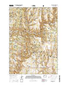
2014 Map of Keys Creek
USGS Topo · Published 2014About this map
The Ochoco National Forest defines this high-desert landscape in central Oregon, where a sophisticated network of small reservoirs and springs supports the arid terrain. Water management is the primary human imprint on the land, seen through numerous catchments like Cinch Reservoir, Charity Reservoir, and the Crossroads Reservoir. The drainage system is anchored by the N Fork Crooked River and its many tributaries, including Keys Creek and the curiously named Stupid Cr. Movement through these timberlands and meadows is dictated by a web of forest service routes, including Arvid Nelson Rd and the Paulina Valley Rd, which connect the various springs and watering holes vital to local ranching and forest management at the start of the 21st century.
Find a feature on this map
63 named features on this map. Tap any name to fly to it.
Don’t see what you’re looking for? This feature index may not catch every label — zoom into the map to look around manually.
Map Details
Editions of this 2014 Keys Creek Map
This is the sole edition of this map. No revisions or reprints were ever made.
Other maps of this area

1932 · Dayville
USGS Topo · 1:125,000

1936 · Dayville
USGS Topo · 1:125,000

1955 · Bend
USGS Topo · 1:250,000

1955 · Canyon City
USGS Topo · 1:250,000

1957 · Bend
USGS Topo · 1:250,000

1958 · Bend
USGS Topo · 1:250,000

1959 · Canyon City
USGS Topo · 1:250,000

1965 · Williams Prairie
USGS Topo · 1:24,000

1966 · Keys Creek
USGS Topo · 1:24,000

1966 · Peterson Point
USGS Topo · 1:24,000