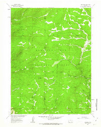
1961 Map of Keystone
USGS Topo · Published 1963About this map
Keystone serves as the focal point of this high-elevation mountain terrain, situated within the Medicine Bow National Forest along the banks of Douglas Creek. The 1961 survey documents a landscape defined by its timber and mineral history, evidenced by the presence of the Keystone Ranger Sta, Keystone Guard Sta, and the Jays Roost Lookout Tower perched on a local high point. The local economy and settlement patterns are clearly linked to resource extraction, with mining claims such as the Golden Key Mine, Sunset Mine, and Gambler Mine distributed near the numerous creek forks and gulches.
Find a feature on this map
43 named features on this map. Tap any name to fly to it.
Don’t see what you’re looking for? This feature index may not catch every label — zoom into the map to look around manually.
Map Details
Editions of this 1961 Keystone Map
3 editions found
Other maps of this area

1906 · Medicine Bow
USGS Topo · 1:125,000

1908 · Medicine Bow
USGS Topo · 1:125,000

1954 · Rawlins
USGS Topo · 1:250,000

1958 · Rawlins
USGS Topo · 1:250,000
1961 · Elkhorn Point
USGS Topo · 1:24,000

1961 · Overlook Hill
USGS Topo · 1:24,000
1961 · Horatio Rock
USGS Topo · 1:24,000

1961 · Medicine Bow Peak
USGS Topo · 1:24,000
1961 · Foxpark
USGS Topo · 1:24,000
1961 · Phantom Lake
USGS Topo · 1:24,000