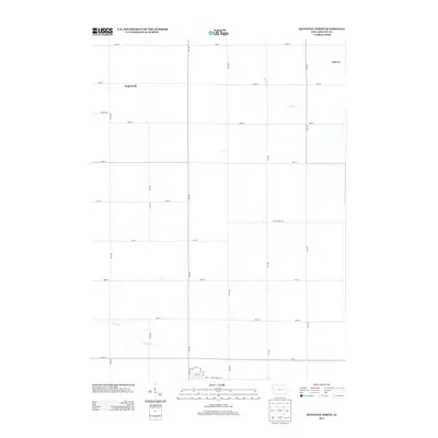
2013 Map of Keystone North
USGS Topo · Published 2013About this map
Rogersville and Geneva sit within the high agricultural plains of Benton County, defined by a rigid grid of section-line roads that dominate this rural landscape. This modern digital survey illustrates the persistent geometry of Iowa's farming country, where the straight lines of routes like 13th Ave and 64th St are interrupted only by the meandering paths of local waterways. The southern portion of the map reveals the upper reaches of Prairie Cr, while Mud Cr drains the northeastern corner near Geneva. These drainages provide the only relief to the strictly ordered township and range system. The map documents the subtle shifts in local infrastructure, including the naming of specialized routes such as 66th Street Dr and 70th Street Dr, which navigate the gentle slopes near the creek beds.
Find a feature on this map
29 named features on this map. Tap any name to fly to it.
Don’t see what you’re looking for? This feature index may not catch every label — zoom into the map to look around manually.
Map Details
Editions of this 2013 Keystone North Map
This is the sole edition of this map. No revisions or reprints were ever made.
Other maps of this area

1954 · Waterloo
USGS Topo · 1:250,000

1954 · Des Moines
USGS Topo · 1:250,000

1955 · Waterloo
USGS Topo · 1:250,000

1956 · Des Moines
USGS Topo · 1:250,000

1957 · Des Moines
USGS Topo · 1:250,000

1965 · Keystone South
USGS Topo · 1:24,000
1965 · Blairstown
USGS Topo · 1:24,000

1968 · Belle Plaine
USGS Topo · 1:24,000

1969 · Des Moines
USGS Topo · 1:250,000
1971 · Elberon
USGS Topo · 1:24,000