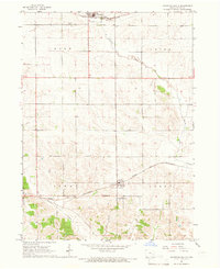
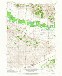
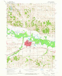
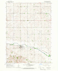
1965 Map of Keystone South
USGS Topo · Published 1966About this map
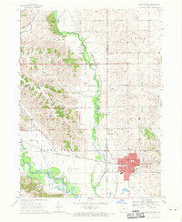
Keystone and Luzerne anchor this mid-1960s agricultural portrait of Benton County, where the transition between the rolling uplands of Kane and Union townships and the valley of Prairie Creek is clearly defined. The landscape is structured by two major rail corridors: the Chicago Milwaukee St Paul and Pacific in the north and the Chicago and North Western running through the south. This era shows a community deeply rooted in its local geography, evidenced by a high density of burial grounds including Keystone Cem, Holy Cross Cem, Lutheran Cem, and the uniquely named International Cem. The presence of a dedicated Sewage Disposal site near the northern rail line suggests the modernization of local infrastructure. Small watercourses like Buckeye Creek and Willow Brook drain the southern townships, carving subtle terrain variations into the surrounding farmland during a period of established mid-century Iowa rural life.
Find a feature on this map
16 named features on this map. Tap any name to fly to it.
Don’t see what you’re looking for? This feature index may not catch every label — zoom into the map to look around manually.
Map Details
Editions of this 1965 Keystone South Map
This is the sole edition of this map. No revisions or reprints were ever made.
Other maps of this area

1954 · Waterloo
USGS Topo · 1:250,000

1954 · Des Moines
USGS Topo · 1:250,000

1955 · Waterloo
USGS Topo · 1:250,000

1956 · Des Moines
USGS Topo · 1:250,000

1957 · Des Moines
USGS Topo · 1:250,000
1965 · Ladora
USGS Topo · 1:24,000
1965 · Marengo
USGS Topo · 1:24,000
1965 · Blairstown
USGS Topo · 1:24,000
1968 · Belle Plaine
USGS Topo · 1:24,000
1968 · Hartwick
USGS Topo · 1:24,000