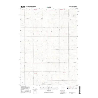
2015 Map of Keystone North
USGS Topo · Published 2015About this map
Keystone serves as the primary hub of this Benton County landscape, situated at the southern edge of a survey defined by its agricultural grid and gentle drainage systems. The northern reaches of the area are bisected by Mud Cr, while Prairie Cr meanders through the southern townships, tracing the low-lying contours of the farmland. This 2015 data illustrates a rural Iowa community organized around a strict section line road system, including key routes like Co Hwy E30 and Co Trunk Hwy V54. For local historians and genealogists, the map is particularly valuable for its precise placement of several rural burying grounds. Smaller family or community landmarks, such as Bishop Grove Cem in the north, LaRue Cem to the east, and Bender Cem near the central-east boundary, provide essential reference points for tracing the early settlement patterns of the region.
Find a feature on this map
38 named features on this map. Tap any name to fly to it.
Don’t see what you’re looking for? This feature index may not catch every label — zoom into the map to look around manually.
Map Details
Editions of this 2015 Keystone North Map
This is the sole edition of this map. No revisions or reprints were ever made.
Other maps of this area

1954 · Waterloo
USGS Topo · 1:250,000

1954 · Des Moines
USGS Topo · 1:250,000

1955 · Waterloo
USGS Topo · 1:250,000

1956 · Des Moines
USGS Topo · 1:250,000

1957 · Des Moines
USGS Topo · 1:250,000

1965 · Keystone South
USGS Topo · 1:24,000
1965 · Blairstown
USGS Topo · 1:24,000

1968 · Belle Plaine
USGS Topo · 1:24,000

1969 · Des Moines
USGS Topo · 1:250,000
1971 · Elberon
USGS Topo · 1:24,000