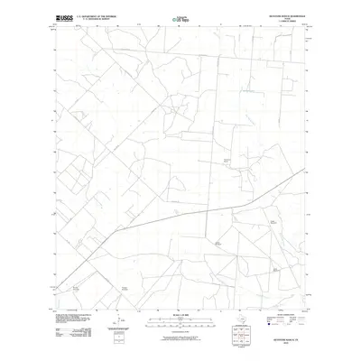
2010 Map of Keystone Ranch
USGS Topo · Published 2010About this map
Keystone Ranch and its surrounding pastoral landscape define this corner of Frio County, where a network of water sources and rural roads supports a specialized ranching economy. The drainage patterns of San Miguel Creek, Black Creek, and Cat Creek organize the terrain, eventually feeding into southern reaches like Huckberry Creek and Live Oak Creek. A notable reliance on groundwater is evident through the naming of several specific sites, including Creek Windmill, Loston Windmill, and Triangle Windmill. These features, along with Howard Lake, provide insight into the infrastructure required for land management in this Texas environment. The road system is dominated by both established farm-to-market routes and local thoroughfares such as Malone Rd and Keystone Rd, which connect the scattered ranching operations across the brushland.
Find a feature on this map
25 named features on this map. Tap any name to fly to it.
Don’t see what you’re looking for? This feature index may not catch every label — zoom into the map to look around manually.
Map Details
Editions of this 2010 Keystone Ranch Map
This is the sole edition of this map. No revisions or reprints were ever made.
Other maps of this area

1927 · Pearsall
USGS Topo · 1:62,500

1934 · Schattel
USGS Topo · 1:62,500

1942 · Dilley
USGS Topo · 1:62,500

1953 · Crystal City
USGS Topo · 1:250,000

1955 · Crystal City
USGS Topo · 1:250,000

1956 · Hindes
USGS Topo · 1:62,500

1961 · Crystal City
USGS Topo · 1:250,000

1964 · Pearsall South
USGS Topo · 1:24,000
1964 · Pearsall North
USGS Topo · 1:24,000

1968 · Crystal City
USGS Topo · 1:250,000