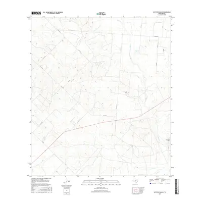
2016 Map of Keystone Ranch
USGS Topo · Published 2016About this map
Keystone Ranch serves as a central landmark in this portion of Frio County, where the brush country landscape is defined by an intricate network of ephemeral watercourses. Significant drainages like San Miguel Cr and Son Miguel Cr meander through the terrain, eventually meeting in the south. The topography rises toward the Marshall Hills in the southeast, while Howard Lake provides a rare localized water feature in the north. The area is crisscrossed by a grid of rural routes and ranch roads, including FM 1582 and Keystone Rd, which facilitate movement between the expansive livestock operations and agricultural plots that dominate the local economy. The mapping of minor tributaries such as Black Cr, Hackberry Cr, and Live Oak Cr reveals the seasonal hydrology essential for ranching in this Texas environment.
Find a feature on this map
25 named features on this map. Tap any name to fly to it.
Don’t see what you’re looking for? This feature index may not catch every label — zoom into the map to look around manually.
Map Details
Editions of this 2016 Keystone Ranch Map
This is the sole edition of this map. No revisions or reprints were ever made.
Other maps of this area

1927 · Pearsall
USGS Topo · 1:62,500

1934 · Schattel
USGS Topo · 1:62,500

1942 · Dilley
USGS Topo · 1:62,500

1953 · Crystal City
USGS Topo · 1:250,000

1955 · Crystal City
USGS Topo · 1:250,000

1956 · Hindes
USGS Topo · 1:62,500

1961 · Crystal City
USGS Topo · 1:250,000

1964 · Pearsall South
USGS Topo · 1:24,000
1964 · Pearsall North
USGS Topo · 1:24,000

1968 · Crystal City
USGS Topo · 1:250,000