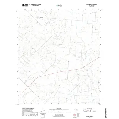
2019 Map of Keystone Ranch
USGS Topo · Published 2019About this map
Keystone Ranch anchors this portion of Frio County, where a complex network of intermittent drainages defines the South Texas brush country landscape. The watershed is dominated by the winding course of San Miguel Cr, which is fed by numerous tributaries including Black Cr, Cat Cr, and Hackberry Cr. These seasonal waterways are central to the region's ranching operations, providing vital drainage and catchment points like Howard Lake. Toward the southeast, the terrain shifts near the Marshall Hills, overlooking the convergence of Live Oak Cr and Mule Cr. The map details a transition from the structured grid of county roads like Co RD 3300 and E Goldfinch RD to the more specialized private routes and farm-to-market roads, such as FM 1582, that service the area's dispersed homesteads and agricultural tracts.
Find a feature on this map
24 named features on this map. Tap any name to fly to it.
Don’t see what you’re looking for? This feature index may not catch every label — zoom into the map to look around manually.
Map Details
Editions of this 2019 Keystone Ranch Map
This is the sole edition of this map. No revisions or reprints were ever made.
Other maps of this area

1927 · Pearsall
USGS Topo · 1:62,500

1934 · Schattel
USGS Topo · 1:62,500

1942 · Dilley
USGS Topo · 1:62,500

1953 · Crystal City
USGS Topo · 1:250,000

1955 · Crystal City
USGS Topo · 1:250,000

1956 · Hindes
USGS Topo · 1:62,500

1961 · Crystal City
USGS Topo · 1:250,000

1964 · Pearsall South
USGS Topo · 1:24,000
1964 · Pearsall North
USGS Topo · 1:24,000

1968 · Crystal City
USGS Topo · 1:250,000