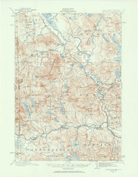
1910 Map of Kezar Falls
USGS Topo · Published 1960About this map
The Saco River serves as the central artery for this Western Maine landscape, where the Maine Central and Bridgton and Saco River RR corridors once facilitated the transport of timber and goods through the river valley. The industrial and educational hubs of the region are clearly defined, featuring the notable Parsonsfield Seminary in the south and the manufacturing presence at Rankins Mill. Small villages and rail stops such as Bridgton Junction and Cornish Sta illustrate the period's reliance on rail connectivity for community survival.
Find a feature on this map
163 named features on this map. Tap any name to fly to it.
Don’t see what you’re looking for? This feature index may not catch every label — zoom into the map to look around manually.
Map Details
Editions of this 1910 Kezar Falls Map
5 editions found

Other maps of this area

1891 · Buxton
USGS Topo · 1:62,500

1891 · Newfield
USGS Topo · 1:62,500

1892 · Buxton
USGS Topo · 1:62,500

1893 · Buxton
USGS Topo · 1:62,500

1893 · Newfield
USGS Topo · 1:62,500

1894 · North Conway
USGS Topo · 1:62,500

1896 · Norway
USGS Topo · 1:62,500

1896 · Sebago
USGS Topo · 1:62,500

1896 · North Conway
USGS Topo · 1:62,500

1909 · Fryeburg
USGS Topo · 1:62,500