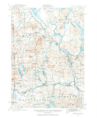
1910 Map of Kezar Falls
USGS Topo · Published 1970About this map
Parsonsfield Seminary stands as a primary landmark in this survey of the Maine-New Hampshire borderlands, reflecting the educational priorities of a rural community at the start of the 20th century. The landscape is defined by the winding Saco River and the Maine Central railroad, which supported the industry of timber and textiles in settlements like Kezar Falls and Cornish. The mapping reveals a network of neighborhood schools, including the Blake School and Colby School, alongside small industrial hubs like Rankins Mill.
Find a feature on this map
162 named features on this map. Tap any name to fly to it.
Don’t see what you’re looking for? This feature index may not catch every label — zoom into the map to look around manually.
Map Details
Editions of this 1910 Kezar Falls Map
5 editions found

Other maps of this area

1891 · Buxton
USGS Topo · 1:62,500

1891 · Newfield
USGS Topo · 1:62,500

1892 · Buxton
USGS Topo · 1:62,500

1893 · Buxton
USGS Topo · 1:62,500

1893 · Newfield
USGS Topo · 1:62,500

1894 · North Conway
USGS Topo · 1:62,500

1896 · Norway
USGS Topo · 1:62,500

1896 · Sebago
USGS Topo · 1:62,500

1896 · North Conway
USGS Topo · 1:62,500

1909 · Fryeburg
USGS Topo · 1:62,500