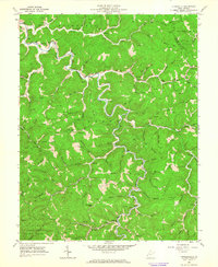
1962 Map of Kiahsville
USGS Topo · Published 1964About this map
Twelvepole Creek winds through the heart of the Wayne County hills, anchoring a landscape defined by the extraction of natural gas and coal in the early 1960s. Numerous Gas Wells and Mines dot the hollows, connected by a network of narrow roads and pipelines. The settlement of Kiahsville serves as a central point for the surrounding rural community, which is marked by family-named landmarks like McComas Mtn and Crackersneck Ridge. Genealogical value is high throughout the quadrangle, with numerous small burial grounds such as Wallace Cem and Jarett Maynard Cem tucked into the hillsides. The southern portion of the map transitions into the protected timberlands of Cabwaylingo State Forest, while local life centers around country schools and churches like Beech Grove Ch and the Lick Creek Sch.
Find a feature on this map
95 named features on this map. Tap any name to fly to it.
Don’t see what you’re looking for? This feature index may not catch every label — zoom into the map to look around manually.
Map Details
Editions of this 1962 Kiahsville Map
2 editions found
Other maps of this area

1887 · Warfield
USGS Topo · 1:125,000

1891 · Warfield
USGS Topo · 1:125,000

1892 · Huntington
USGS Topo · 1:125,000

1898 · Huntington
USGS Topo · 1:125,000

1902 · Midkiff
USGS Topo · 1:62,500

1907 · Midkiff
USGS Topo · 1:62,500

1909 · Wayne
USGS Topo · 1:62,500

1909 · Midkiff
USGS Topo · 1:62,500

1910 · Holden
USGS Topo · 1:48,000

1910 · Naugatuck
USGS Topo · 1:48,000